Building an efficient backend for mobile app, which uses geolocation and spatial data (demo of using PostGIS and GeoDjango)
INTRO
In this note I would like to show you how to create a piece of mobile app’s backend, which uses geospatial data. Instead of conventional demo showing how to make simple nearby queries e.g for some restaurants, I demonsrate how to build a piece of backend for an app like Tinder.
TECHNOLOGY STACK
- GeoDjango (beuatifully wraping GEOS)
- PostGIS (module for GIS to Postgres)
- Django REST Framework (nice library for building REST-full API’s using Django)
WHY PostGIS?
Teoretically we could use any database for storing the latitude and longitude and make nearby-queries using universal mathematical formula known as Haversine formula. Below I present two django views. The first uses a standard MySQL database (but in fact it could be any database offering the basic math like cos, sin) and the second one makes use of GeoDjango (with PostGIS behind):
def nearby_spots_haversine(request, lat, lng, radius=5000, limit=50):
    """
    WITHOUT use of any external library, using raw MySQL and Haversine Formula
    http://en.wikipedia.org/wiki/Haversine_formula
    """
    radius = float(radius) / 1000.0
    query = """SELECT id, (6367*acos(cos(radians(%2f))
               *cos(radians(latitude))*cos(radians(longitude)-radians(%2f))
               +sin(radians(%2f))*sin(radians(latitude))))
               AS distance FROM demo_spot HAVING
               distance < %2f ORDER BY distance LIMIT 0, %d""" % (
        float(lat),
        float(lng),
        float(lat),
        radius,
        limit
    )
    queryset = Spot.objects.raw(query)
    serializer = SpotWithDistanceSerializer(queryset, many=True)

    return JSONResponse(serializer.data)
vs:
def nearby_spots_postgis(request, lat, lng, radius=5000, limit=50):
    """
    WITH USE OF GEODJANGO and POSTGIS
    https://docs.djangoproject.com/en/dev/ref/contrib/gis/db-api/#distance-queries
    """
    user_location = fromstr("POINT(%s %s)" % (lng, lat))
    desired_radius = {'m': radius}
    nearby_spots = Spot.objects.filter(
        mpoint__distance_lte=(user_location, D(**desired_radius))).distance(
        user_location).order_by('distance')[:limit]
    serializer = SpotWithDistanceSerializer(nearby_spots, many=True)

    return JSONResponse(serializer.data)
Well, we could use an even more minimalistic approach (and neglect details like the curvature of the earth, which for small-radius-nearby quries is really not a big issue) and use an approach like this demonstrated by me on stackoverflow that is: filter objects between certain lattitudes and longitudes, the interesection of which forms a square circumscribed about circle. One more thing we then need is to filter out objects inside the square and outisde the circle (pooint-center > radius), which can be done in Python to avoid further database overload.
Writing raw SQL queries isn’t too elegant, and its usage in Django is seen as an antipattern. Additionally we stick to a certain database, and we lose the easiness (given by django’s ORM) of switching between different databases. On the other hand the choice of GeoDjango is also a kind of small limitation, we can choose among the following database backends:
- django.contrib.gis.db.backends.postgis,
- django.contrib.gis.db.backends.mysql,
- django.contrib.gis.db.backends.oracle,
- django.contrib.gis.db.backends.spatialite,
but thanks to the choice of GeoDjango we can get rid of writing raw SQL queries, and whats more we get plethora of classes and methods to deal with geospatial data, what will be described bellow.
Mentioned database backends support the geospatiall functionallity to a diffrent extent. Their comparision can be found here.
Why PostGIS?
Because it offers the most powerfull functionality for GeoDjango, and is an extension of one of the most popular databases for Django development - postgres.
GeoDjango - plethora of possibilites
As said, using GeoDjango we get a plethora of classes and methods to deal with geospatial data, which I’ll try to briefly discuss here:
Let’s start with avaliable datataypes for storing our geospatial data:
- PointField - is a stanard data type for storing latitude and longitude. Maybe you also find it awkward, but in intialization the order of passing arguments is as follows: first longitude, then latitude.
Floats representing values are stored in two element tuple, accessible by:
some_pointfiled.coords
there are two ways of intialization:
standard:
last_location = Point(21.006841063502, 52.245934009551)
from string:
last_location = 'POINT(21.006841063502, 52.245934009551)'
-
PolygonField - for storing polygons; perfect for selecting areas.
-
LineStringField - stores points connected by line; ideal for selecting paths on maps.
-
MultiPointField - structure for storing multiple not-connected points.
-
MultiLineStringField - structure for storing multiple obiects of LineStringField type
-
MultiPolygonField - structure for storing multiple obiects of PolygonField type.
-
GeometryCollectionField - collection for storing heterogenous objects (Poly, points, etc).
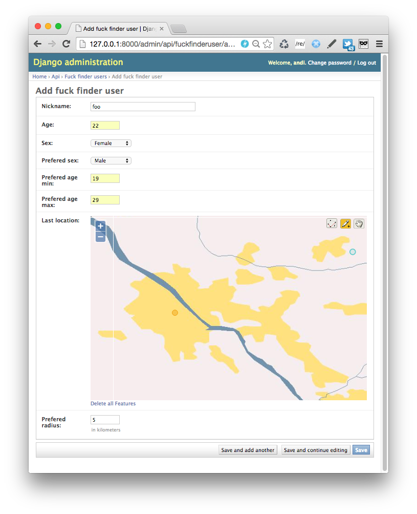
It is worth noticing, that while registering in the admin model with geospatial data types, we get support with simple map widgets for selecting Point, Polygon or path. The sad thing is that the default backend is not using Google Maps, but rather very poor maps. But it is possbile to replace the default maps with GogoleMaps using django-google-maps.

The next important element of the module is django.contrib.gis.measure allowing different kinds of measuring the distance between points and other objects. Class Distance (can be also aliased by D) also allows easy manipulation of different units of measure (avaliable measures). In this module we find also the class Area very handy every time we need to deal with calculating A geographic area.
We appreciate GeoDjango fully while using spatial lookups and distance lookups offering us rich possibilites of filtering geospatial data. Below a short list of methods, which can be applied to fields of class GeometryField:
a) (spatial lookups):
- bbcontains, bboverlaps, contained, contains, contains_properly, coverdby, covers, crosses, disjoint, equals, exact, same_as, intersects, overlaps, relate, touches, within, left, right, overlaps_left, overlaps_right, overlaps_above, overlaps_below, strictly_above, strictly_below
b) (distance lookups):
- distance_gt, distance_gte, distance_lt, distance_lte, dwithin
dwithin works very similar to distance_lt but produces different SQL and has different performance (dwithin makes better uses of geo indexing)- more can be found here and here
FuckFinder API requirements
Let’s call our demo app “FuckFinder”, what in my opinion is a good reflection of the philosophy of Tinder.
In this demo we limit ourselves to creating:
a) simplified user model
b) crucial view responsible for finding useres matching users criteria and of course most importantly matching the criterium of geolocation, and returning calculated distance between users.
MODEL of FuckFinder user:
class FuckFinderUser:
    nickname
    age
    sex
    prefered_sex
    prefered_age_min
    prefered_age_max
    last_location
    prefered_radius
VIEW returning users nearby matching queries:
GET /fetch_fuckfinder_proposals_for/<nick_of_finder>/<current_latitude>/<current_longitiude>/
-
for given user and its current geoposition
-
returned users must be inside radius of requesting user and the requesting user must also be inside radius of each returned user
-
less important from geo-litemotive, but anyway: matching sex preferences (taking in consideration homosexual/heterosexual differentiation) and age preferences.
Example of HTTP request:
curl GET http://127.0.0.1:8000/api/fetch_fuckfinder_proposals_for/andi/52.22967/21.01222/
Example HTTP response:
[
  {
    "id": 2,
    "prefered_sex": "M",
    "sex": "F",
    "nickname": "j",
    "age": 22,
    "prefered_age_min": 19,
    "prefered_age_max": 30,
    "last_location": {
      "latitude": 52.255750894546,
      "longitude": 20.990216732027
    },
    "prefered_radius": 15,
    "distance": 0.9902584497169999
  }
]
INSTALING POSTGIS and CONFIGURING DJANGO
info hot to install postgis can be found here: http://postgis.net/install/
install GEOS:
http://www.kyngchaos.com/software/frameworks#geos
after installing postgres and GEOS, run psql
create db:
create database fuckfinder_db;
connect to it:
\connect fuckfinder_db
after connecting to db we need to add geo-extensions:
-- Enable PostGIS (includes raster)
CREATE EXTENSION postgis;
-- Enable Topology
CREATE EXTENSION postgis_topology;
-- fuzzy matching needed for Tiger
CREATE EXTENSION fuzzystrmatch;
-- Enable US Tiger Geocoder
CREATE EXTENSION postgis_tiger_geocoder;
check POSTGIS version:
postgis_lib_version();
as a tupple we add it to django settings:
POSTGIS_VERSION = (2, 1, 3)
we use as db backend in django:
django.contrib.gis.db.backends.postgis
and NOT standard postgres django.db.backends.postgresql_psycopg2
and in INSTALLED_APPS add:
django.contrib.gis
IMPLEMENTATION:
(...)
class FuckFinderUser(models.Model):
    nickname = models.CharField(max_length=250, unique=True)
    age = models.IntegerField(validators=[MinValueValidator(18), MaxValueValidator(130)])
    sex = models.CharField(max_length=1, choices=SEX_CHOICES)
    prefered_sex = models.CharField(max_length=1, choices=SEX_CHOICES)
    prefered_age_min = models.IntegerField(validators=[MinValueValidator(18), MaxValueValidator(130)])
    prefered_age_max = models.IntegerField(validators=[MinValueValidator(18), MaxValueValidator(130)])
    last_location = models.PointField(max_length=40, null=True)
    prefered_radius = models.IntegerField(default=5, help_text="in kilometers")

    objects = models.GeoManager()
(...)
wersja wstępna views.py
(...)
def fetch_fuckfinder_proposals_for(request, nick_of_x, current_latitude, current_longitiude, limit=10):

    finder = get_object_or_404(FuckFinderUser, nickname=nick_of_x)
    finder_location = Point(float(current_longitiude), float(current_latitude))

    if finder.prefered_sex == finder.sex:
        # deal with homosexual
        candidates = FuckFinderUser.objects.filter(
            prefered_sex=finder.sex,
            sex=finder.prefered_sex,
            age__range=(finder.prefered_age_min, finder.prefered_age_max),
            prefered_age_min__lte=finder.age,
            prefered_age_max__gte=finder.age,
        ).exclude(nickname=finder.nickname)
    else:
        # deal with heterosexual:
        candidates = FuckFinderUser.objects.filter(
            sex=hetero_desires(finder),
            age__range=(finder.prefered_age_min, finder.prefered_age_max),
            prefered_age_min__lte=finder.age,
            prefered_age_max__gte=finder.age,
        ).exclude(sex=F('prefered_sex')).exclude(nickname=finder.nickname)

    # do geo queries
    candidates_inside_finder_radius_and_vice_versa = candidates.filter(
        last_location__distance_lte=(
            finder_location,
            D(km=min(finder.prefered_radius, F('friendly_rate'))))
        ).distance(finder_location).order_by('distance')[:limit]

    serializer = FuckFinderUserListSerializer(
        candidates_inside_finder_radius_and_vice_versa, many=True)

    return JsonResponse(serializer.data, safe=False)
PERFORMANCE
To test API preformance we need first generate some resonable big data, to get such run:
python manage.py generate_1M_ff_users
skrypt generates 1M (milion) randomized FuckFinderUsers with following schema:
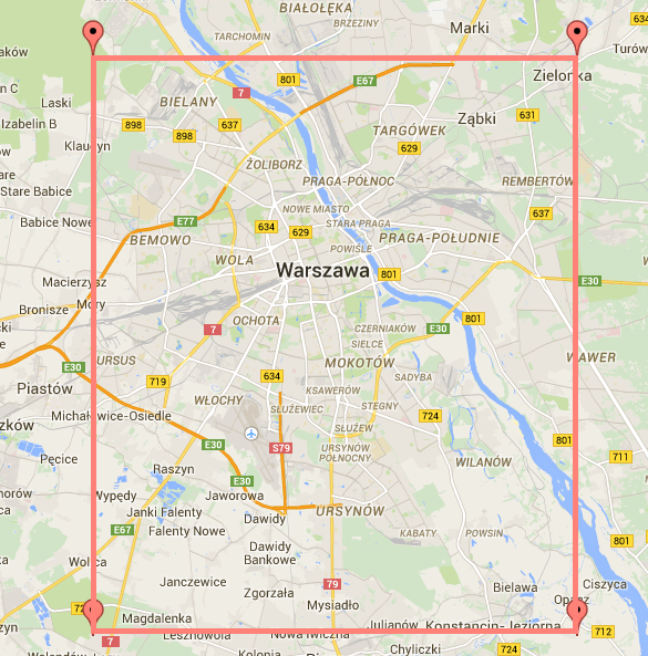
- last_location random choice of latitude, longitued in range:
- dla LAT 52.09 - 52.31
- dla LNG 20.87 - 21.17

- age at random from range 18-55,
- desired age for finding desired_max_age, desired_min_age we pick at random number from 1, 2, 3, 5, 8, 13 and add (for max) or susbtract (for min) from users age
- sex with equal probability
- orientation (desired_sex) pick at random with following distribution (hetero: 0.95, homo: 0.05)
- prefered radius pick at random from 5, 10, 15, 20, 25, 30
In a deterministic way we create:
python manage.py generate_andi_user
Let’s check what is response time and how big is the retuned JSON for:
http://127.0.0.1:8000/api/fetch_fuckfinder_proposals_for/andi/52.22862/21.00195/
For me the response time was 46 seconds (of course it may vary depending of hardware you have), and the size of returned JSON was above 20MB. It is not acceptable for mobile devices which often use the mobile network, and even on WIFI it is not a resonable size.
Let’s have a look if order of filtering [sex+age, geo] vs [geo, sex+age] will make a difference. It differs only by 3 seconds. Not a big deal.
Let’s have a look at the automatically created index in postgres:
fuckfinder_db=# \d+ api_fuckfinderuser
(...)
Indexes:
    "api_fuckfinderuser_pkey" PRIMARY KEY, btree (id)
    "api_fuckfinderuser_nickname_key" UNIQUE CONSTRAINT, btree (nickname)
    "api_fuckfinderuser_last_location_id" gist (last_location)
Has OIDs: no
Let’s try playing with adding indexes to all other fields:
fuckfinder_db=# fuckfinder_db=# \d+ api_fuckfinderuser
(...)
Indexes:
    "api_fuckfinderuser_pkey" PRIMARY KEY, btree (id)
    "api_fuckfinderuser_nickname_key" UNIQUE CONSTRAINT, btree (nickname)
    "api_fuckfinderuser_age_5da72621f56542a8_uniq" btree (age)
    "api_fuckfinderuser_last_location_id" gist (last_location)
    "api_fuckfinderuser_prefered_age_max_4fb7a9bd5f0e8ddc_uniq" btree (prefered_age_max)
    "api_fuckfinderuser_prefered_age_min_4fb7a10960310f8a_uniq" btree (prefered_age_min)
    "api_fuckfinderuser_prefered_sex_22dd447fdfd9a3b6_uniq" btree (prefered_sex)
    "api_fuckfinderuser_sex_774e0911fdfeec21_uniq" btree (sex)
Has OIDs: no
After doing so, we get even worses results. Let’s try doing it for resonable fields (age, sex), which shouldn’t change in time a lot.
fuckfinder_db=# \d+ api_fuckfinderuser
(...)
Indexes:
    "api_fuckfinderuser_pkey" PRIMARY KEY, btree (id)
    "api_fuckfinderuser_nickname_key" UNIQUE CONSTRAINT, btree (nickname)
    "api_fuckfinderuser_age_5da72621f56542a8_uniq" btree (age)
    "api_fuckfinderuser_last_location_id" gist (last_location)
    "api_fuckfinderuser_sex_774e0911fdfeec21_uniq" btree (sex)
Has OIDs: no
We made something better, but still we are transfering huge JSON (more than 20MB).
How we can make it smaller, and make our API more efficient? We can introudce pagination of results.
PAGINATION
The idea of pagination is simple, we split results we want to serve into pages containing only k-first results, and link to the next result page, and on futrhter pages also linkt to previous ones.
To implement pagination we will use django_core.paginator, as well as PaginationSerializer from Django Rest Framework.
The calculated on the go distance field in queryset and our geo field last_location require explicit information on how they should be serialized. We specify it in to_representation of Serializer class.
(...)
class FuckFinderUserListSerializer(serializers.ModelSerializer):
    prefered_sex = serializers.ChoiceField(choices=SEX_CHOICES, default='male')
    sex = serializers.ChoiceField(choices=SEX_CHOICES, default='male')

    class Meta:
        model = FuckFinderUser

    def to_representation(self, instance):
        ret = super(FuckFinderUserListSerializer, self).to_representation(instance)
        pnt = fromstr(ret['last_location'])
        ret['last_location'] = {'longitude': pnt.coords[0], 'latitude': pnt.coords[1]}
        ret['distance'] = instance.distance.km
        return ret


class PaginatedFuckFinderUserListSerializer(PaginationSerializer):

    class Meta:
        object_serializer_class = FuckFinderUserListSerializer
better version of views.py with use of pagination:
@api_view(['GET', ])
def fetch_fuckfinder_proposals_for(request, nick_of_finder, current_latitude, current_longitiude):

    finder = get_object_or_404(FuckFinderUser, nickname=nick_of_finder)
    finder_location = Point(float(current_longitiude), float(current_latitude))

    candidates = FuckFinderUser.objects.filter(
        last_location__distance_lte=(
            finder_location,
            D(km=min(finder.prefered_radius, F('prefered_radius'))))
        ).distance(finder_location).order_by('distance')

    if finder.prefered_sex == finder.sex:
        # deal with homosexual
        candidates_inside_finder_radius_and_vice_versa = candidates.filter(
            prefered_sex=finder.sex,
            sex=finder.prefered_sex,
            age__range=(finder.prefered_age_min, finder.prefered_age_max),
            prefered_age_min__lte=finder.age,
            prefered_age_max__gte=finder.age,
        ).exclude(nickname=finder.nickname)
    else:
        # deal with heterosexual:
        candidates_inside_finder_radius_and_vice_versa = candidates.filter(
            sex=finder.hetero_desires(),
            age__range=(finder.prefered_age_min, finder.prefered_age_max),
            prefered_age_min__lte=finder.age,
            prefered_age_max__gte=finder.age,
        ).exclude(sex=F('prefered_sex')).exclude(nickname=finder.nickname)

    paginator = Paginator(candidates_inside_finder_radius_and_vice_versa, 20)

    page = request.QUERY_PARAMS.get('page')

    try:
        result = paginator.page(page)
    except PageNotAnInteger:
        result = paginator.page(1)
    except EmptyPage:
        result = paginator.page(paginator.num_pages)

    serializer_context = {'request': request}
    serializer = PaginatedFuckFinderUserListSerializer(
        result, context=serializer_context)
    return Response(serializer.data)
The use of pagination seems making a big change for our problem. Even someone desperate for love probaly wouldnt browse through several thousands of results at once (in our example without pagination it was: 89,5k !!) ;-) While setting pagination to k=20 results, we came down from 20MB repsonse size to 5KB, and the repsonse time is less than 2 seconds.
Response looks as follows:
{
  "count": 14035,
  "next": "http://127.0.0.1:8000/api/fetch_fuckfinder_proposals_for/andi/52.22862/21.00195/?page=2&format=json",
  "previous": null,
  "results": [
    {
      "id": 806494,
      "prefered_sex": "M",
      "sex": "F",
      "nickname": "34c2c31d-2b80-4bd7-acf2-c77538e4fb01",
      "age": 25,
      "prefered_age_min": 20,
      "prefered_age_max": 38,
      "last_location": {
        "latitude": 52.228934198475436,
        "longitude": 21.00258680522904
      },
      "prefered_radius": 20,
      "distance": 0.9902584497169999,
    },
    (...)
  ]
}
REPO
Full code can be found here:
https://github.com/andilabs/django-tinder